Backpacking Glacier National Park: Belly River to Elizabeth Lake
Four days moving from autumn into winter through Cosley Lake and Elizabeth Lake, carrying camera gear, listening to wolves, and watching fresh snow change the mountains overnight.
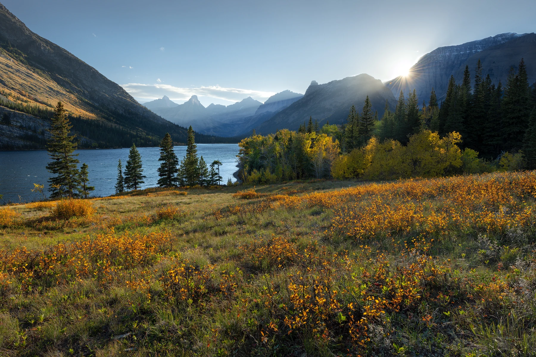
Crown Of The ContinentCosley Lake, Belly River, Glacier National Park
Route
Belly River to Cosley and Elizabeth Lakes
Distance
Approximately 26–28 miles over four days
Season
Late September, with rain, wind, and fresh snow
I went into Glacier's Belly River country in late September knowing the weather could change faster than our route. Over four days, my girlfriend, my sister, her partner, and I walked from the Belly River trailhead to Cosley Lake, continued to the head of Elizabeth Lake, moved to the foot of the lake, and then hiked back out.
The trip sat directly on the line between fall and winter. Autumn shrubs still carried warm color around the lakes, but rain and strong wind moved through the valleys. Temperatures dropped below freezing, clouds erased the high peaks, and fresh snow appeared above us after the storms passed.
I had spent that summer guiding in the Belly River, but traveling through it on a personal backpacking trip changed the pace. We were carrying everything we needed for several days, and I was also carrying the camera equipment I wanted when the weather broke. Every photograph was tied to the miles, wet gear, cold mornings, and decisions that got us into position.
Into the Belly River
The Belly River trail enters Glacier from the park's northeastern edge and quickly moves away from the road. Forest gives way to river crossings, broad valleys, lakes, and the steep walls of the Lewis Range. The scale develops gradually. By the time the trail system begins branching toward places like Cosley Lake and Elizabeth Lake, the park no longer feels arranged around roadside viewpoints.
Our first day began with an early rise, a drive of about three and a half hours, and a hike of roughly nine miles to Cosley Lake. Official trail segments put the direct distance near eight and a half miles, while my field notes round the walking day closer to nine. That is the kind of difference that appears naturally between a mapped trail, a GPS track, and the steps taken around camp.
As we moved deeper into the valley, forests and river corridors connected everything around us. This is where I feel Glacier's wilderness character most strongly. The mountains are not scenery placed beyond a pullout. They form the walls of the route, direct the weather, hold wildlife habitat, and determine where a person can move.
Cosley Lake and Crown Of The Continent
We reached Cosley Lake shortly before sunset. Mount Cleveland, Glacier's highest peak, rises beyond the water, with Whitecrow Mountain, the Stoney Indian Peaks, Pyramid Peak, and Cosley Ridge shaping the wider view. The lake sits well inside the Belly River trail network, far enough from the trailhead that evening light belongs mostly to the people camped there.
I made Crown Of The Continent as the sun dropped near Mount Cleveland. Warm autumn vegetation edged the foreground while the lake and mountains carried cooler color. Broken cloud held the remaining light above the ridge. The photograph describes the geography better than a wide scenic claim ever could: water, forest, mountain, and weather all occupy the same connected space.
Glacier is part of the larger Crown of the Continent ecosystem. From Cosley, that name feels less like a label. Several miles into the backcountry, surrounded by valleys extending beyond sight, I could sense the continuity of the landscape rather than a collection of separate attractions.
Peaks above the Belly River
The mountains in these photographs are specific, not generic background. From Cosley Lake, Mount Cleveland rises with Whitecrow Mountain, the Stoney Indian Peaks, Pyramid Peak, and Cosley Ridge shaping the horizon. Later, above Elizabeth Lake, Seward Mountain became the wall of fresh snow and cloud that defined the final morning.
Mount Cleveland deserves special attention. The National Park Service lists it as Glacier National Park's highest point at 10,466 feet, and from the Belly River country that height gives the whole skyline a different gravity. It is part of the broader Crown of the Continent landscape: a place where water, weather, wildlife movement, and alpine habitat all meet in the same rugged terrain.
One of Glacier's most fascinating high-alpine stories is almost invisible from the trail. Each summer, millions of army cutworm moths leave the hot plains and move into Glacier's cool alpine talus. They are not there to lay eggs. As adults, they shelter beneath loose rock during the day, feed on alpine flower nectar at night, and build extraordinary fat reserves by late summer.
That tiny insect becomes a serious food source for grizzlies. Bears climb into steep, broken talus fields and turn rocks to feed on moths by the thousands. Recent Glacier research identified more than 100 moth-foraging sites and found that suitable army cutworm moth habitat is concentrated in a very small portion of the park's alpine landscape.
Public research summaries do not identify Mount Cleveland itself as a documented major moth-foraging site, so it is better understood here as part of the broader high-mountain world where this kind of alpine food web can exist. The point is larger and more interesting: the massifs above places like Cosley and Elizabeth are not just dramatic photographic subjects. They are active alpine ecosystems where a grizzly can be drawn high into rock, wind, and snow by an insect only a fraction of its size.
Wolves somewhere across the lake
After the stars came out at Cosley, a pack of wolves began howling from across the lake. The sound continued for about fifteen minutes. We could not see what they were doing, and I do not need to supply a reason. Hearing them carry through a dark valley was enough.
On our final walk out, several wolves crossed the trail about twenty feet ahead of us. One paused and looked in our direction before moving on. Three traveled through the forest roughly parallel to us for a short distance. Once our group was back together, wolves nearby howled and others farther into the valley answered for around ten minutes.
Knowing wolves live in Glacier is different from seeing and hearing them where roads and buildings are absent. The encounter did not turn the trip into a wildlife spectacle. It clarified the landscape. The deeper I travel into Glacier on foot, the more I experience it as an ecosystem rather than a collection of scenic viewpoints.
Their presence felt powerful because the valley was already intact and wild.
From Cosley Lake to Elizabeth Lake
The next day we continued through the trail network toward Elizabeth Lake Head. My saved records put that leg between roughly six and seven and a half miles, depending on the recording and where the day's measurement began. The official mapped segments total close to the upper end of that range. I prefer to preserve that honest variation rather than publish false precision.
Late in the season, bridges across some rivers and streams had already been removed. We took off our boots and crossed running water on foot. Rain moved through the forest, the trail became wet, and low cloud settled into the valley as we approached camp. At Elizabeth Lake Head, the surrounding mountains appeared and disappeared while we made dinner and tried to keep camp organized in the weather.
On day three, we moved only 1.6 miles from the head of Elizabeth Lake to the campground at its foot. The short day gave us time beside the lake, but it did not make the weather gentle. Wind traveled the length of the water and continued through the night. In a remote camp, wind changes the ordinary parts of the day: where you cook, how quickly you lose warmth, what stays dry, and whether sleep comes easily.
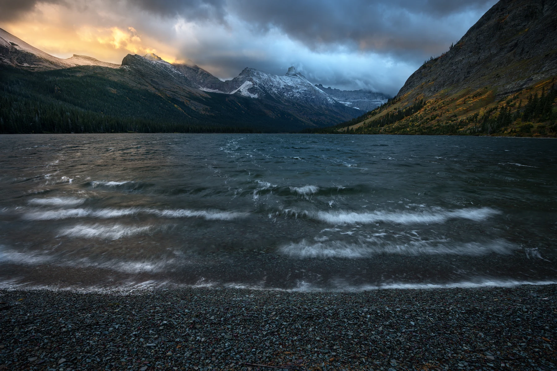
The fourth morning
When morning arrived, fresh snow covered the mountains above Elizabeth Lake. Seward Mountain rose into low cloud, the sky held pink, purple, gold, and cold blue, and high winds drove waves toward shore. The air was bitterly cold. The lake no longer looked like the place we had walked beside the previous afternoon.
I made Cold Front in that brief combination of first light, fresh snow, moving cloud, and rough water. The image is not separate from the discomfort surrounding it. We packed quickly because we still had 9.5 miles to walk back to the Belly River trailhead. Being camped at the lake made the photograph possible, but the conditions also set the limits of how long I could work.
When fall and winter occupy the same valley
Late September in Glacier can hold more than one season at once. That overlap is visually rich, but it creates practical work for anyone carrying a backpack.
From inside the backpack
Rain means wet gear and slower camp chores. Mud changes footing. Shorter days reduce the margin for a delayed start. Wind can turn a calm campsite into an exposed place, and a temperature drop that seems modest on a forecast feels different after hours outside.
Fresh snow also changes route judgment. It can hide higher terrain, make surfaces slick, and signal that conditions above camp are becoming more serious.
From behind the camera
Wet autumn vegetation becomes saturated, warm shrubs separate from newly white peaks, and low clouds simplify mountain walls that can feel crowded in clear light. Openings arrive briefly, revealing only part of a summit or allowing light to move across one slope.
Those conditions shaped both photographs from this trip. Crown Of The Continent carries the remaining warmth of fall; Cold Front records how quickly winter began taking over.
Photographing while backpacking
Backpacking and photography work together because I am already in the landscape when the light changes. At Cosley, I did not have to drive to an overlook for sunset. At Elizabeth Lake, I was beside the water before dawn while the storm was still moving through. Along the trail I could respond to rain-darkened forests, autumn plants, changing clouds, and intimate scenes that would never become destinations on their own.
The tradeoff is weight. A camera body, lenses, tripod, batteries, and protection from rain all compete with food, shelter, insulation, and safety equipment. I carry a focused kit and decide before the trip what kinds of photographs matter most. A useful lens that stays accessible is worth more than several options buried at the bottom of a pack.
Weather protection is part of the camera system. I keep spare batteries dry and warm, carry more lens cloths than I think I will need, and make sure photography never delays a stream crossing, a cold group, or a necessary move toward camp.
Example Belly River backpacking itinerary
This is the sequence from my four-day trip, checked against the National Park Service wilderness campground map and trail data. Distances remain approximate because field tracks and official segments measure slightly different start and stop points.
Day 1
Belly River Trailhead → Cosley Lake
The route passes through the Belly River system to the Cosley Lake wilderness campground. My day included an early drive and a roughly nine-mile track.
About 8–9 mi
Day 2
Cosley Lake → Elizabeth Lake Head
Trail connections return through the Belly River network toward Elizabeth Lake, with river and stream crossings that can change late in the season.
About 6–7.5 mi
Day 3
Elizabeth Lake Head → Elizabeth Lake Foot
A short move along the lake between two separate wilderness campgrounds, leaving time to photograph and respond to weather.
1.6 mi
Day 4
Elizabeth Lake Foot → Belly River Trailhead
The final walk follows the official trail segments back through the Belly River valley to the trailhead.
9.5 mi
This is a route example, not a current booking plan. Campsites, bridges, trail conditions, wildlife closures, and permit rules change. Build an itinerary from current NPS information and distances that fit your own experience.
Looking for Boulder Pass?
That backpacking route deserves its own guide. Check out the Boulder Pass backpacking route.
Planning a Glacier wilderness trip
The route on a map is only the beginning. Glacier's wilderness camps are limited, itineraries are tied to specific campgrounds, and late-season conditions can remove the assumptions a summer trip depends on.
Permits and camps
An overnight wilderness permit is required. Cosley Lake, Elizabeth Lake Head, and Elizabeth Lake Foot are distinct campgrounds with limited sites. Start with the current NPS permit process and wilderness campground map.
Conditions and closures
Check the park's road, trail, and campground status close to departure. In late September, shorter daylight, freezing nights, removed bridges, early snow, and reduced services can all change the work required.
Food and wildlife
Carry bear spray where it is immediately accessible, follow current food-storage rules, make noise in low-visibility terrain, and keep wildlife encounters from becoming photography pursuits. The wolves we saw were part of the valley, not subjects to follow.
Weather and margin
Build enough time and equipment into the route for wet gear, cold mornings, slow crossings, and an itinerary adjustment. A camera should never consume the margin needed to keep moving safely.
For a broader look at timing, weather, composition, and access, read my Glacier National Park photography field guide. The work from these trips also continues through my Mountain Landscapes and Autumn Colors collections.
The miles are part of the photograph.
Cosley Lake and Elizabeth Lake stayed with me because the weather, wildlife, camps, and long walk were inseparable from the images. Backpacking let me experience Glacier as a connected landscape and be present when late autumn became winter overnight.